

|
|
Fourth day in a row of storm chasing and yet again another nice set-up with a moist SWly flow with 1300 CAPE and LIs of -4 (these were actually upgraded on the later run) with -40C cool pool aloft and surface convergence to the E with enough shear for brief updraught/downdraught separation so storms would be organised for a time with multicells or line convection being the likely outcome. Slack flow with Sfc meant that funnel clouds were possible and convective precipitation was forecast for the midlands and E of N. Ireland. Forecasting wasn't a problem, I had already decided that our target area would be the N and W side of the Lough Neagh basin with the option of moving E to Antrim later if needed, however I was also expecting activity in my home area over the Sperrins so my plan was to start the chase in this area then adapt to the weather as the day advanced, it would turn out that all my target areas would have multiple storms.
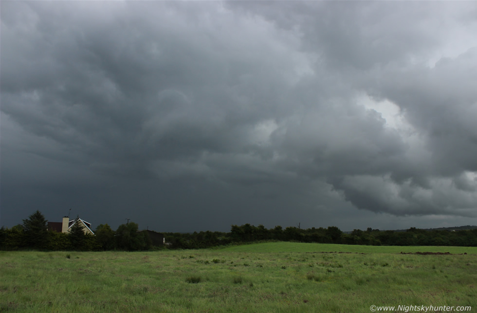
Roisin was joining me yet again for the chase however she would have to leave by early afternoon and with the radar looking excellent even by early morning we got organised and hit the road, by late morning we where at the bottom of Glenshane Pass in Oak Leaf filling station where we had tea and sandwiches, success arrived even sooner than we had anticipated. We where parked at the rear of the filling station eating when within min's we were surrounded by strong convection, there was a cell to the W, another to the E, and more to the S and plenty of healthy towers sprouting upward in real time, I estimate that there must have been five cells in our vicinity at the same time and what impressed me most was how tall and solid they were for this time of the day, it was 12.00 and a cell had started producing curtains of precip and hail stones near Slieve Gallion and was in the process of moving towards Lough Neagh then grew in size as it approached us, it felt great out in the warm sunshine in a T-shirt watching a storm approach while eating a sandwich at my leisure, we could hear rumbles of thunder then the cell hit with heavy rain and small hail so we sat in the car watching various bolts of the i-c variety flash above the filling station, it was interesting to watch the reactions from the customers, some were oblivious, others ran for cover and yet others stood fascinated watching the lightning with great interest, it was good to see the latter.
We relocated to the top of Glenshane and parked the nose of the car facing E and for some time we watched numerous cells move near the lough with random rumbles, it seemed there can be too much of a good thing as cells were too numerous and they began to train close together getting in each other's way and soon it would be a matter of time before their combined outflow would kill off any warm inflow air, furthermore the cloud was filling in at mid levels there too hiding structure so all we could see was grey clouds, our thoughts however were interrupted by rumbles of thunder behind us so we changed location further W along the Glenshane Pass then got off the main road and watched several storms rumbling over the mountain however once again structure was hard to see and cloud was getting in the way, I was getting concerned that this day wasn't going to produce any photo opps despite the nice CAPE as everything was getting messy and it seemed to be raining all the time with nothing to see so I needed to think this one through and come up with a plan.
Roisin had to leave so I headed back home were I could clear my head and get a look at the bigger picture. Back in my kitchen with a brew I could see on the laptop that things had well and truly kicked off with quite a few storms across the country and a lot of lightning however I was looking for something strong and isolated with structure, my prayers were answered, a strong line of storms in the Republic had crossed over the border into SE N. Ireland and where moving N along the E of the country, the radar was extremely impressive and the line was covering tens of miles with red and white cores, reports and images came in of a beautiful close range funnel cloud in Co. Down which got my full attention, the funnel was stunning and rotating over the rooftops and had been produced by that line of storms, so what was I to do?, other chasers online said getting to Newry would be a great position and it certainly looked to be a good area however it would take me an hour to get there and I didn't know the roads which was putting me off so I had to come up with a new plan. I looked at the radar again and flicked between the two updates checking motion, I mentally projected where the line would go and based on the last update I figured that if I left now, and I mean now, I might be able to intercept the N cells of the line as they moved N over Lough Neagh and one place jumped out immediately based on the radar - Antrim Marina at the NE corner of Lough Neagh. The decision was made and there was no time to waste as I needed to get there before the storm did so I left the remainder of my warm brew on the table and got my gear ready, I asked my mother if she wanted to come along and she did so we got in the car as fast as we could and hit the road.
 |
We made good progress along the carriageway near Toome however we ended up getting side-tracked by nice convection to the E so we took the road at the roundabout for Ballymena and ended up on a country road with the car parked nose down at a 60 degree angle with a dodgy handbrake watching the back of a cell, after seeing that funnel cloud online I was on full funnel hunt and was watching every base I could find, mum and I watched the cell over the quiet fields however as much as I wanted to see it there was no rotation at all, here it is in front of us moving R to L with inflow area to the R, I then became aware of a lorry up the road which was parked with driver watching us, there was an isolated country house near us and from his point of view we may have looked suspicious as if we were staking out the property so I got out from the car and made a show of taking images with the camera held in a very clear manner, there was nothing to shoot but I just kept clicking with camera pointing high up at the clouds, he got the picture - no pun intended - then left us to it. After all that drama our cell decayed however explosive updraughts now appeared behind us over the trees and they looked serious business and heading in the direction of the lough so I decided we were not going to waste any more time here and just stick to our target area so we got back on the road, made a turn at Toome roundabout, then headed E towards Antrim.
 |
This was the view as we made our way along the motorway, the sky was closing in with big towers bubbling all around us, I took this sneaky shot through the front windscreen - I wasn't looking through the viewfinder - I just took multiple images and this one came out. I got my mum to take video as I drove while explaining how to work the video camera in the process, she did a very good job for spare of the moment filming having never done it before.
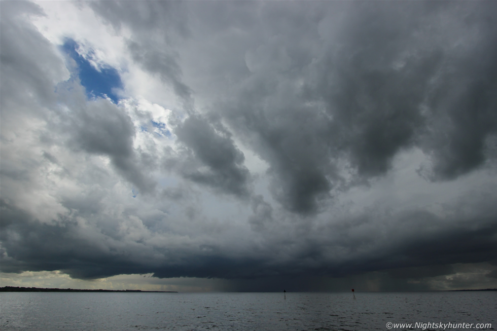 |
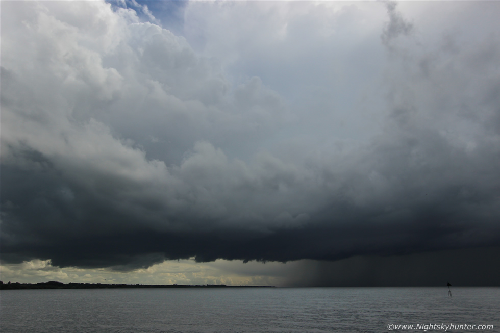
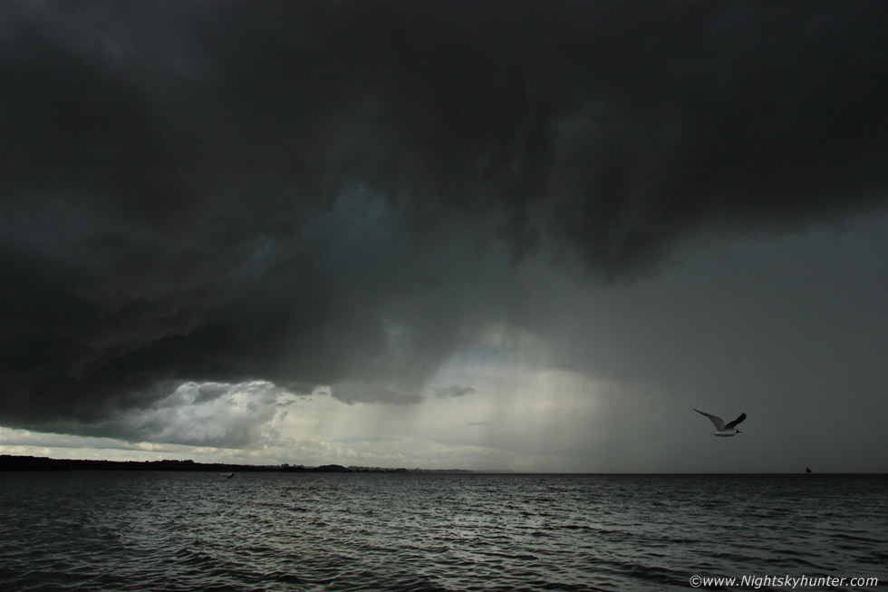
We arrived at Antrim Marina, my burning desire to see what was over the lough was negated by trees and buildings and it seemed forever to get over the numerous speed bumps on the road however once we entered the car park and cleared the obstructions I looked to the S and saw our storm, it looked very impressive and mean looking so we drove to the far end of the car park as close as possible to the shore and got out to shoot the storm. It had just left land at the SW corner of the lough in Co. Down and was now in the process of slowly crossing the centre of the lough making a beeline for the NE corner and it was clear it was heading straight for us and Antrim. I set my video camera on the car roof and began recording in the hope of making a time lapse video then mum and I walked to the edge of the wall beside the water and watched this beautiful storm approach, in the above wide angle image the base was over the centre of Lough Neagh yet the anvil was visible over our heads inland through gaps in the mid level cloud, the anvil was huge and was blown downrange ahead of the storm by the stronger winds aloft, there were large well defined mammatus 'bags' hanging from the anvil too, seeing mammatus at the rear of a storm anvil is common however getting it on the forward end and this solid is always a good sign of a very strong updraught lifting air from the surface up to the higher portion of the Troposphere.
 |
This was absolute heaven, we were able to relax in the warm and humid afternoon air with the sunlight dancing on the water with the relaxing sound of the lough gently lapping against the shore accompanied by the sound of seagulls and swans while angry thunder rumbled in the distance and gradually grew louder as the storm neared. I was informed by my Dad that a fisherman friend of his who operates in this area experienced this very same storm and it was notable enough for him to share his experiences of it with him, he was about to cross the lough in his boat when he become so frightened by the lightning and hail stones that he turned around and went back to shore, he said he had never experienced a storm like it in his life and he had been fishing on the lough since he was a boy!
 |
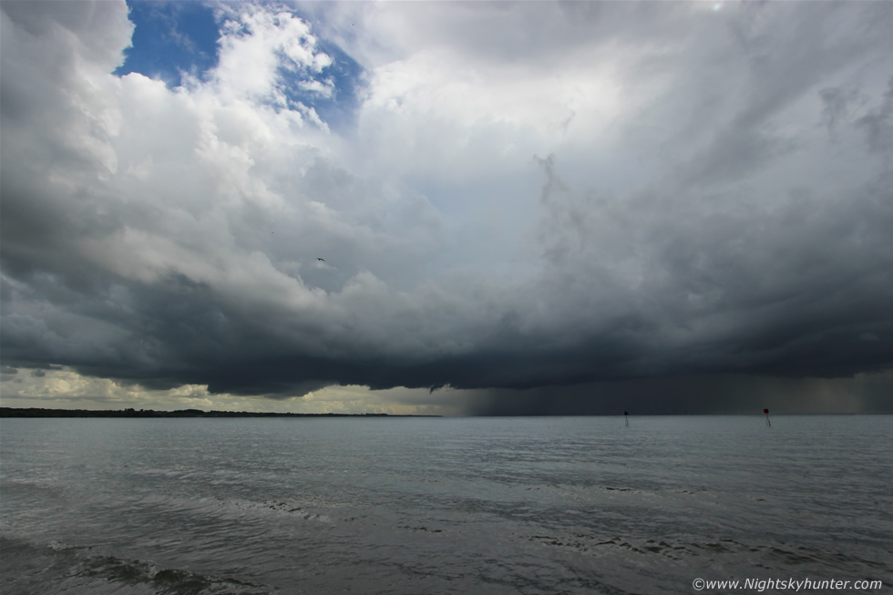
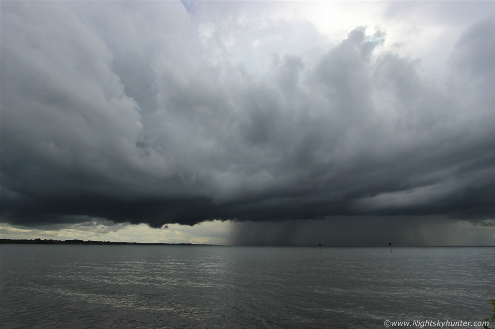
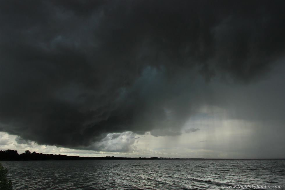
The precip core was clearly very heavy with curtains of hail stones embedded within the darkness and in front of the core was a tidy well defined shelf cloud forming along the storm's gust front which you can see as a dark straight edge, to the L of this and ahead of the storm was a stunning rain free base (RFB) above which several powerful updraughts could be seen gleaming white in the afternoon sunshine. I noticed that the entire storm was rotating merrily while thunder boomed and rumbled making me smile with delight, our positioning was utter perfection as this was the northern most storm on that line on radar, this was the main storm of the day in the area making this the fourth day in a row of success.
 |
What impressed me most was the striking rock solid cloud structure indicating that a very intense storm was showing off in front of us, this is the kind of structure I hunt for, check out the low base of the storm, the Lifted Condensation Level (LCL) was very low this day so storms would be truly surfaced based and close to the ground and when this happens you can be sure of more dramatic structure and a better chance of the base interacting with the local environment which can greatly aid funnel cloud and tornado development - especially when there is good surface convergence in the area and enough support aloft, this was happening now and although I could see no funnels the large scale rotation was most impressive and even more so because it wasn't an isolated area that was rotating but rather the entire storm itself seemed to be turning like a supercell.
 |
It was a truly beautiful storm with very frequent lightning, we didn't see many c-gs however there were very rapid in-cloud (i-c) bolts within the core however the abundance of thunder suggested there was much more lightning than we could see which where no doubt behind the core or up inside the updraught. I removed the video camera from the car roof then set it up on the wall beside us and filmed the front of the cell as it inched closer. Lough Neagh is an amazing place with its very own micro climate and time and time again it has produced a rich bounty of severe weather, I will never forget seeing this large body of water frozen over solid three times within two years which was a sight I will never forget, also the severe gusts of wind across the open water, the flooding along the shore and the frequent thunderstorms and funnel clouds which happen here are a testament to it's atmospheric magic.
 |
When I first learned to drive I chased storms here and have always been amazed by how they seem to come to life over this famous lough with countless episodes of rotation, funnels and cloud motion not to mention its history of documented tornadoes and waterspouts - the most recent of which happened only a few weeks earlier and all in a very low CAPE environment with convergence. It is my belief that local convergence happens here due to differential heating between land and water combined with an abundance of moisture which can really feed and intensify storms. 2014 in particular has been a prolific year for storms over Lough Neagh, I have been shocked by the amount of times I have watched storms explode when they encounter the lough, this day was another example of this and we had the privilege of watching the entire process evolve right in front of us without a drop of rain. Just visualize this living breathing storm cell - a colossal mountain of moisture moving upwards fed by more than 1300 CAPE with ice crystals flowing out aloft in the shape of an anvil with lightning discharges inside with the base sucking in rich supplies of moist warm air while rain cooled air sinks in front of the storm in the form of a gust front sending wind across the lough while the base rotates with just enough speed shear to keep this process balanced while thunder rumbled and hail stones fall back through to the base creating a cool pool of air which generated more convection ahead in one organised process of multicell formation.
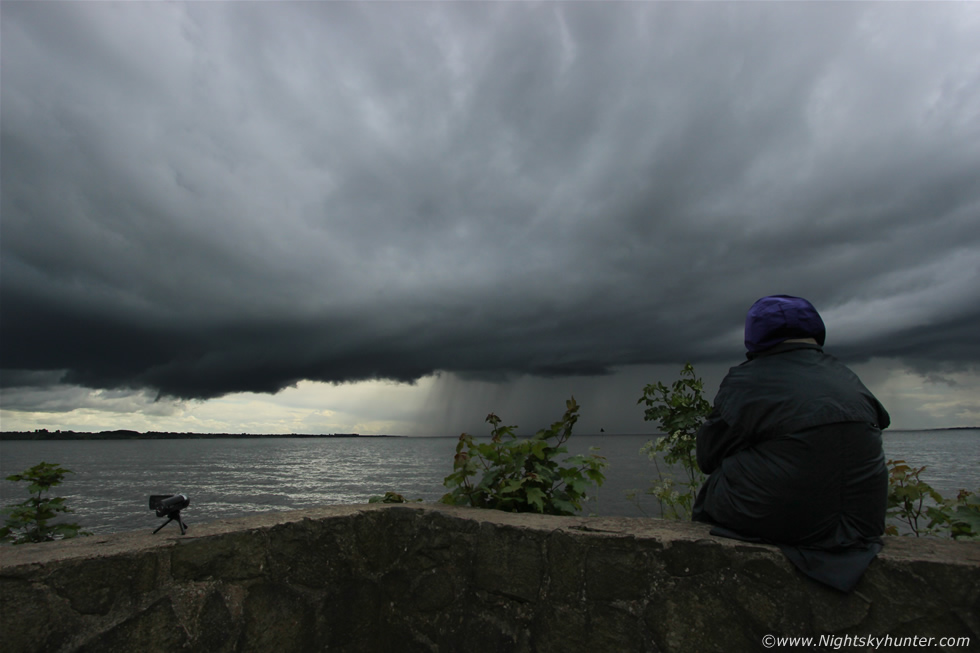 |
Mum enjoying herself and feeling content sitting on the wall watching the storm get closer, the gust front was now affecting us on shore with cool air blasting across the lough dropping the temp and warning us that the storm was getting close enough to effect us with an increased danger of close lightning, I had a quick look around and saw other cars parked in the area with their occupants watching the storm intently, some were even taking video through the windscreen with mobile phones trying to catch lightning, note my video camera perched on the wall to the L.
 |
The storm was now almost on top of us and dangerously close, these were with the 10mm ultra wide angle, the birds were flying away from the storm to a more sheltered part of the lough and drops of rain were falling while loud thunder roared and had that sound which said ''you are next'' - I love this moment, an intense concoction of excitement and fear when the air becomes charged and you know you shouldn't be out so I pushed my luck a little further for last minute images, mum was back in the car and when I looked behind me everyone else was gone and it seemed I was the only one standing out, I only had another minute then I would need to get back in the car too as this was getting intimidating under the storm out in the open.
 |
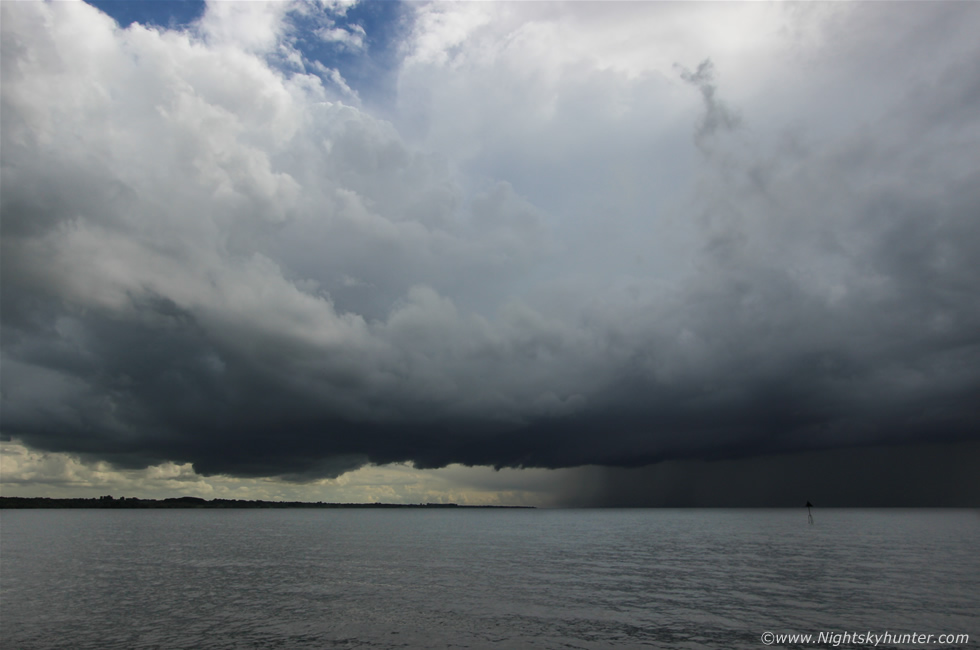
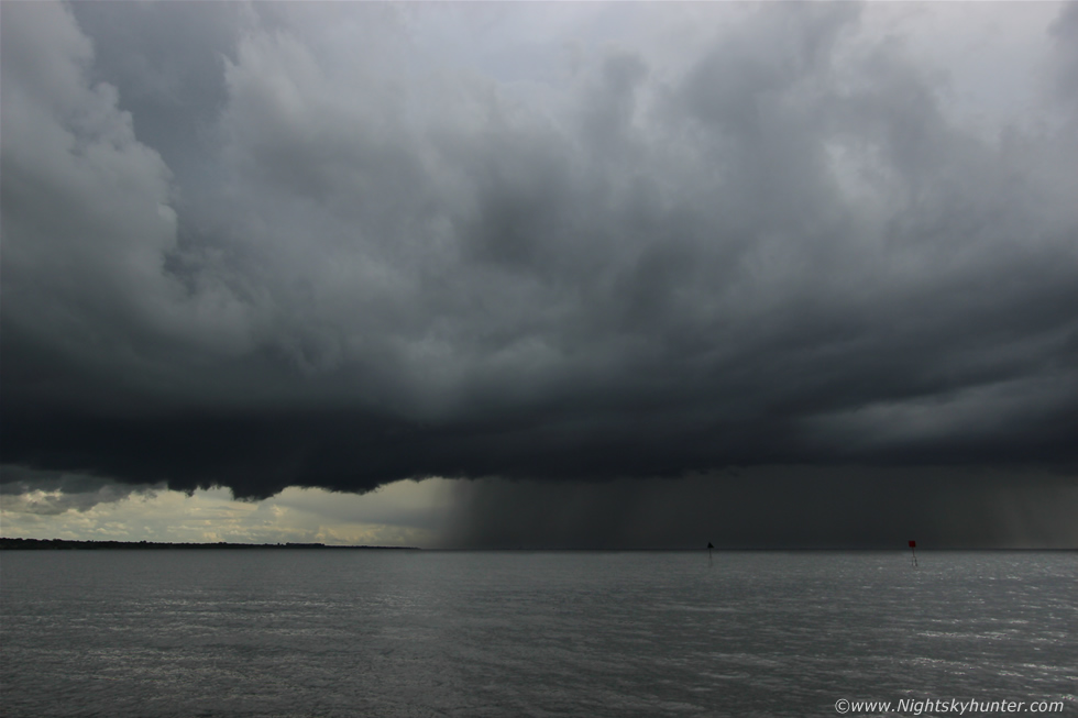
This is underneath the shelf cloud/gust front of the storm as it moved from R to L from water to land, check out the vibrant green colour under the guster in both images indicative of a good hail core growing in there, I could see rotation too, I was looking through the viewfinder looking at this scene and had my finger resting on the shutter button, I then had it half pressed to focus then just before I applied full pressure a stunning red c-g bolt with dramatic branches struck the water in front of me which delayed my response by a second, this was the image and had I pressed it half a second earlier I would have had it on camera!, that was quite intense and exciting to experience and I felt sure I had it on video however when I checked the footage it had struck outside the field of view to the R.
I ran back to the car and took shelter then mum and I watched as the core passed directly over us and as it did so it seemed to intensify even further, it felt like we were sitting there for a long time listening to torrential rain and hail stones with very frequent overhead lightning which became even more active then the core passed over the trees behind the car and moved in over Antrim town itself. Through the front windscreen a clearance appeared and the rain gradually eased then finally stopped to be replaced by the sound of the gulls and swans again who now deemed it save to return to the water once more. Blue sky appeared over the lough and overhead mid level cloud parted to reveal a large anvil with sinking mammatus then the thunder became more faint and distant and our storm was gone. I would learn later when I got online at home that we were not the only observers impressed by this storm, I saw many excited reports from Antrim of a ''nasty storm'' with highly active lightning and big hail stones, the radar images from this storm were impressive to say the least with a very large white core over the lough at the NE side exactly where we and Antrim town were located, the precip rate was at the very top of the scale so it seemed that Lough Neagh had done it again as a storm producing machine and as the sun came out and convection waned I wondered when the next tornado in this area was due and when it did I hoped I would be fortunate enough to be in the rite place at the rite time like this day.
Full HD chase video starting in Maghera watching convection with Roisin then quickly moving to the motorway then Antrim Marina storm with several time lapse segments.
Another HD video only this is entirely time lapse footage at 16x, 32x and 64x speed showing the forming shelf cloud, the downdraught across the lough and the dramatic large scale storm rotation. This day brought an end to our four days chasing and I have to say it was a great adventure and extreme success with verified personal forecasts and multiple storm intercepts on all four days covering territory both to the N and S of the country and below the border with somewhere in the order of 45 hours on the road, it was nice to end it all with a beautiful storm like this in my home area over this magical lough which always has a special place in my heart and with that said I can't wait for the next storm outbreak - I already miss that sweet sound of thunder, thanks very much for reading.
Martin McKenna